
1952 Map of Crab Orchard
USGS Topo · Published 1953About this map
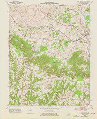
Crab Orchard serves as a focal point in this early 1950s survey of Lincoln County, where the Louisville and Nashville railroad intersects with the historic Wilderness Road. The landscape is defined by the winding course of the Dix River and numerous tributaries like Walnut Flat Creek and Cedar Creek. A significant historical landmark, the William Whitley House State Shrine, sits near the center of the sheet, preserved amidst a network of rural settlements.
Find a feature on this map
44 named features on this map. Tap any name to fly to it.
Don’t see what you’re looking for? This feature index may not catch every label — zoom into the map to look around manually.
Map Details
Editions of this 1952 Crab Orchard Map
2 editions found
Other maps of this area

1892 · Richmond
USGS Topo · 1:125,000

1893 · London
USGS Topo · 1:125,000

1897 · Richmond
USGS Topo · 1:125,000

1897 · London
USGS Topo · 1:125,000

1905 · Harrodsburg
USGS Topo · 1:125,000

1952 · Halls Gap
USGS Topo · 1:24,000

1952 · Eubank
USGS Topo · 1:24,000

1952 · Paint Lick
USGS Topo · 1:24,000

1952 · Lancaster
USGS Topo · 1:24,000

1952 · Stanford
USGS Topo · 1:24,000