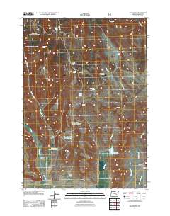
2011 Map of Buchanan
USGS Topo · Published 2011About this map
Buchanan and the surrounding ranching landscape in Harney County are defined by a network of seasonal water sources and family-named landmarks. The map documents the vital importance of water management in this arid region, showing several engineered points such as the Upper Jones Canyon Reservoir, Lower Jones Canyon Reservoir, and Corcoran Reservoir. The imprint of early settlement is visible through named properties and structures like the Mary Oard Homestead, Long Cabin, and the Poujade Ranch near Cow Creek Valley. This 2011 survey by the U.S. Geological Survey captures a rural territory where natural features like Oard Flat and Poujade Field serve as anchors for local history and geography. Multiple springs, including Demeris Spring and Rattlesnake Spring, feed the drainage systems of Rock Creek and Cow Creek, illustrating the environmental constraints and adaptations of High Desert ranching life.
Find a feature on this map
30 named features on this map. Tap any name to fly to it.
Don’t see what you’re looking for? This feature index may not catch every label — zoom into the map to look around manually.
Map Details
Editions of this 2011 Buchanan Map
This is the sole edition of this map. No revisions or reprints were ever made.
Other maps of this area

1955 · Burns
USGS Topo · 1:250,000

1958 · Burns
USGS Topo · 1:250,000

1959 · Burns
USGS Topo · 1:250,000

1959 · Harney
USGS Topo · 1:62,500

1961 · Calamity Butte
USGS Topo · 1:62,500

1968 · Van
USGS Topo · 1:62,500

1973 · Buchanan
USGS Topo · 1:24,000

1973 · Mahon Creek
USGS Topo · 1:24,000

1973 · Carson Point
USGS Topo · 1:24,000
1978 · Stinkingwater Pass
USGS Topo · 1:24,000