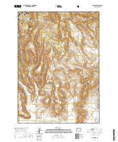
2020 Map of Buchanan
USGS Topo · Published 2020About this map
Malheur National Forest dominates the northwestern reaches of this high-desert landscape, where the terrain breaks into a complex network of canyons and plateaus. The small settlement of Buchanan sits at the junction of Crane-Buchanan Rd and Big Rock Cr, serving as a remote outpost in eastern Harney County. The distribution of water is central to life here, evidenced by numerous named sources like Demeris Spring, Boggan Springs, and Rattlesnake Spring that dot the drainages.
Find a feature on this map
33 named features on this map. Tap any name to fly to it.
Don’t see what you’re looking for? This feature index may not catch every label — zoom into the map to look around manually.
Map Details
Editions of this 2020 Buchanan Map
This is the sole edition of this map. No revisions or reprints were ever made.
Other maps of this area

1955 · Burns
USGS Topo · 1:250,000

1958 · Burns
USGS Topo · 1:250,000

1959 · Burns
USGS Topo · 1:250,000

1959 · Harney
USGS Topo · 1:62,500

1961 · Calamity Butte
USGS Topo · 1:62,500

1968 · Van
USGS Topo · 1:62,500

1973 · Buchanan
USGS Topo · 1:24,000

1973 · Mahon Creek
USGS Topo · 1:24,000

1973 · Carson Point
USGS Topo · 1:24,000
1978 · Stinkingwater Pass
USGS Topo · 1:24,000