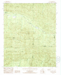
1985 Map of Buck Knob
USGS Topo · Published 1986About this map
Ouachita National Forest dominates this mid-1980s landscape, where several mountain ridges converge near the borders of Scott, Polk, and Montgomery Counties. The terrain is defined by the steep slopes of Mill Creek Mountain to the north and Fourche Mountain across the center, with the Ouachita Trail winding through the high ground. Local activity is concentrated in the northern valleys near the Mill Creek Recreation Area, which features a campground, bath house, and picnic area. While much of the land remains undeveloped forest, human imprints appear in the form of a shale pit, a prominent radio tower atop Buck Knob, and the small settlement of Highland near the southern border. The intricate hydrology of the region is mapped in detail, including the courses of Irons Fork and Mill Cr, alongside local family or place-named landmarks like Mast Mountain and Brushy Knob.
Find a feature on this map
38 named features on this map. Tap any name to fly to it.
Don’t see what you’re looking for? This feature index may not catch every label — zoom into the map to look around manually.
Map Details
Editions of this 1985 Buck Knob Map
This is the sole edition of this map. No revisions or reprints were ever made.
Other maps of this area

1879 · Poteau Mountain
USGS Topo · 1:62,500

1887 · Poteau Mountain #1
USGS Topo · 1:62,500

1887 · Mount Ida #2
USGS Topo · 1:62,500

1890 · Mount Ida
USGS Topo · 1:125,000

1890 · Poteau Mountain
USGS Topo · 1:125,000

1899 · Poteau Mountain
USGS Topo · 1:125,000

1939 · Waldron
USGS Topo · 1:62,500

1940 · Waldron
USGS Topo · 1:62,500

1941 · Waldron
USGS Topo · 1:62,500

1949 · Waldron
USGS Topo · 1:62,500