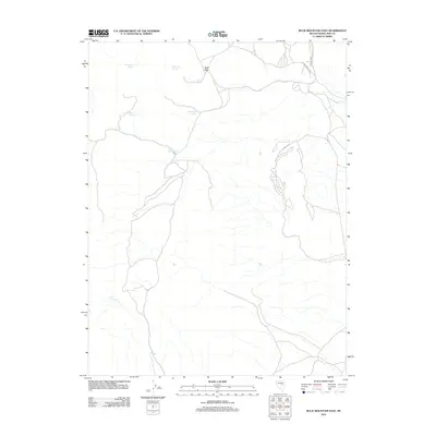
2012 Map of Buck Mountain East
USGS Topo · Published 2012About this map
Buck Pass serves as a central landmark in this high-elevation corner of White Pine County, where the desert landscape is defined by its vital water sources. The map documents a network of named springs that have historically sustained movement through this arid terrain. From Cottonwood Springs and Springtime Springs in the north to Beck Spring at the southern edge, these points mark the rare locations where moisture reaches the surface. The distribution of features like Woodchuck Spring, Little Willow Spring, and Rock Springs suggests a territory where survival and transit are dictated by the geography of the water table. This 2012 survey provides a precise look at these remote landmarks as they appeared in the early 21st century.
Find a feature on this map
9 named features on this map. Tap any name to fly to it.
Don’t see what you’re looking for? This feature index may not catch every label — zoom into the map to look around manually.
Map Details
Editions of this 2012 Buck Mountain East Map
This is the sole edition of this map. No revisions or reprints were ever made.
Other maps of this area

1956 · Ely
USGS Topo · 1:250,000

1957 · Buck Mountain
USGS Topo · 1:62,500

1957 · Cold Creek Ranch
USGS Topo · 1:62,500

1959 · Ely
USGS Topo · 1:250,000

1963 · Ely
USGS Topo · 1:250,000
1982 · Long Valley Slough
USGS Topo · 1:24,000

1982 · Sunshine Well
USGS Topo · 1:24,000
1982 · Sunshine Well NW
USGS Topo · 1:24,000

1985 · Newark Lake
USGS Topo · 1:100,000
1990 · Buck Mountain East
USGS Topo · 1:24,000