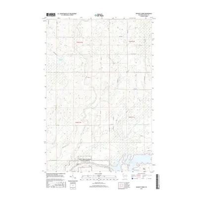
2015 Map of Buckety Creek
USGS Topo · Published 2015About this map
The Saint Croix National Scenic Riverway anchor this Douglas County landscape, where the Saint Croix River meets its tributaries in a complex network of wetlands and flowages. This 2015 survey reveals how local water management and conservation efforts have shaped the terrain, specifically around the Saint Croix Flowage and the northern Moose Br Flowage. Rural life is centered on small settlements and creek crossings, such as Scott Bridge and the namesake Buckety Creek. The map documents a mix of named family landmarks and rural routes, including Ole Larson and Twin Brg, providing a record of property divisions and access points within the timber and water-rich environment of northwest Wisconsin. From the southern expanse of Bubar Island to the winding course of the Moose River, the map captures the hydrologic character of the region as it existed in the mid-2010s.
Find a feature on this map
40 named features on this map. Tap any name to fly to it.
Don’t see what you’re looking for? This feature index may not catch every label — zoom into the map to look around manually.
Map Details
Editions of this 2015 Buckety Creek Map
This is the sole edition of this map. No revisions or reprints were ever made.
Other maps of this area

1945 · Solon Springs
USGS Topo · 1:48,000

1947 · Minong
USGS Topo · 1:48,000

1949 · Solon Springs
USGS Topo · 1:48,000

1949 · Minong
USGS Topo · 1:48,000

1949 · Webb Lake
USGS Topo · 1:48,000

1949 · Patzau
USGS Topo · 1:48,000

1953 · Ashland
USGS Topo · 1:250,000

1953 · Duluth
USGS Topo · 1:250,000

1954 · Amnicon Lake
USGS Topo · 1:24,000
1954 · Lyman Lake
USGS Topo · 1:24,000