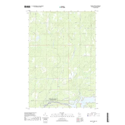
2019 Map of Buckety Creek
USGS Topo · Published 2019About this map
The Saint Croix River and its expansive Saint Croix Flowage dominate the southern landscape of this Douglas County quadrangle. This area, managed as the Saint Croix National Scenic Riverway, represents a critical watershed where the Moose River and Buckety Creek converge into the larger river system. The presence of Bubar Island and the Scott Bridge crossing indicates the historic importance of these waterways for both navigation and local transit. North of the flowage, the land is marked by a network of rural roads with family-associated names like Ole Larson and Jackson Box Rd, interspersed with numerous small creeks such as Spring Creek and Carlson Creek. The N Country National Scenic Trail winds through the wetlands and forests, highlighting the region's enduring character as a preserved wilderness corridor in northern Wisconsin.
Find a feature on this map
38 named features on this map. Tap any name to fly to it.
Don’t see what you’re looking for? This feature index may not catch every label — zoom into the map to look around manually.
Map Details
Editions of this 2019 Buckety Creek Map
This is the sole edition of this map. No revisions or reprints were ever made.
Other maps of this area

1945 · Solon Springs
USGS Topo · 1:48,000

1947 · Minong
USGS Topo · 1:48,000

1949 · Solon Springs
USGS Topo · 1:48,000

1949 · Minong
USGS Topo · 1:48,000

1949 · Webb Lake
USGS Topo · 1:48,000

1949 · Patzau
USGS Topo · 1:48,000

1953 · Ashland
USGS Topo · 1:250,000

1953 · Duluth
USGS Topo · 1:250,000

1954 · Amnicon Lake
USGS Topo · 1:24,000
1954 · Lyman Lake
USGS Topo · 1:24,000