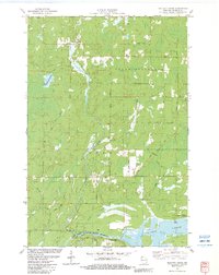
1982 Map of Buckety Creek
USGS Topo · Published 1983About this map
The St Croix River corridor defines this portion of Douglas County, where the northern wetlands and forests meet the protected waters of the St Croix National Scenic Riverway. In the early 1980s, the landscape was a complex network of glacial drainages and flowages, including the expansive St Croix Flowage and the smaller Moose Branch Flowage. The townships of Solon Springs and Gordon are marked by a transition from managed timberlands and Gravel Pits to recreational sites like the Gordon Flowage Campground.
Find a feature on this map
35 named features on this map. Tap any name to fly to it.
Don’t see what you’re looking for? This feature index may not catch every label — zoom into the map to look around manually.
Map Details
Editions of this 1982 Buckety Creek Map
This is the sole edition of this map. No revisions or reprints were ever made.
Other maps of this area

1945 · Solon Springs
USGS Topo · 1:48,000

1947 · Minong
USGS Topo · 1:48,000

1949 · Solon Springs
USGS Topo · 1:48,000

1949 · Minong
USGS Topo · 1:48,000

1949 · Webb Lake
USGS Topo · 1:48,000

1949 · Patzau
USGS Topo · 1:48,000

1953 · Ashland
USGS Topo · 1:250,000

1953 · Duluth
USGS Topo · 1:250,000

1954 · Amnicon Lake
USGS Topo · 1:24,000
1954 · Lyman Lake
USGS Topo · 1:24,000