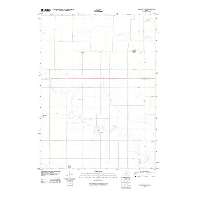
2010 Map of Buckeye East
USGS Topo · Published 2010About this map
Cottage and the surrounding Hardin County farmland are defined by the winding course of the South Fork Iowa River as it cuts through the agricultural grid. This 2010 survey reflects a rural landscape where small settlements like Racine, Ellis, and Buckeye serve as anchors for the local community. The distribution of historic burial sites, including Cottage Cemetery, Lincoln Cemetery, and the Tipton Norwegian Cemetery, provides significant genealogical value, tracing the settlement patterns of early families in the region. To the northeast, the Iowa Falls Municipal Airport marks a modern utility contrast to the surrounding natural drainage of Beaver Creek and Tipton Creek. The map documents the enduring intersection of Iowa's river systems with the persistent rectilinear road network of the prairie.
Find a feature on this map
20 named features on this map. Tap any name to fly to it.
Don’t see what you’re looking for? This feature index may not catch every label — zoom into the map to look around manually.
Map Details
Editions of this 2010 Buckeye East Map
This is the sole edition of this map. No revisions or reprints were ever made.
Other maps of this area

1954 · Waterloo
USGS Topo · 1:250,000

1955 · Waterloo
USGS Topo · 1:250,000

1979 · Iowa Falls West
USGS Topo · 1:24,000

1979 · Buckeye West
USGS Topo · 1:24,000

1979 · Buckeye East
USGS Topo · 1:24,000

1979 · Popejoy
USGS Topo · 1:24,000

1979 · New Providence
USGS Topo · 1:24,000

1979 · Iowa Falls East
USGS Topo · 1:24,000

1979 · Hubbard
USGS Topo · 1:24,000
1979 · Radcliffe
USGS Topo · 1:24,000