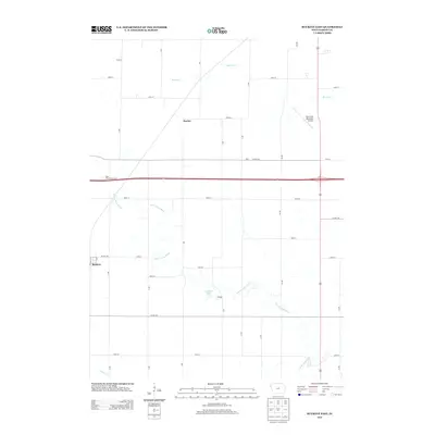
2013 Map of Buckeye East
USGS Topo · Published 2013About this map
The S Fork Iowa River meanders through this portion of Hardin County, anchoring a landscape defined by agricultural road grids and small rural settlements. Small communities like Buckeye, Racine, Ellis, and Cottage are scattered across the quadrangle, serving as local centers within the extensive network of numbered roads and county highways such as Co HWY-d25 and Co HWY-d41. The presence of Gehrkes Lake and the Twin Elms Access Area indicates preserved recreational pockets amidst the cultivated fields.
Find a feature on this map
24 named features on this map. Tap any name to fly to it.
Don’t see what you’re looking for? This feature index may not catch every label — zoom into the map to look around manually.
Map Details
Editions of this 2013 Buckeye East Map
This is the sole edition of this map. No revisions or reprints were ever made.
Other maps of this area

1954 · Waterloo
USGS Topo · 1:250,000

1955 · Waterloo
USGS Topo · 1:250,000

1979 · Iowa Falls West
USGS Topo · 1:24,000

1979 · Buckeye West
USGS Topo · 1:24,000

1979 · Buckeye East
USGS Topo · 1:24,000

1979 · Popejoy
USGS Topo · 1:24,000

1979 · New Providence
USGS Topo · 1:24,000

1979 · Iowa Falls East
USGS Topo · 1:24,000

1979 · Hubbard
USGS Topo · 1:24,000
1979 · Radcliffe
USGS Topo · 1:24,000