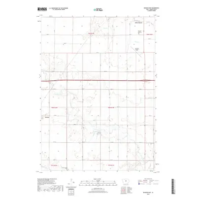
2018 Map of Buckeye East
USGS Topo · Published 2018About this map
Iowa Falls anchors the northern portion of this Hardin County landscape, where the agricultural grid is interrupted by the meandering course of the S Fork Iowa River and Beaver Cr. The small settlement of Buckeye sits at the western edge, serving as a focal point for the surrounding rural townships. This 2018 survey reveals a terrain defined by its water systems, including the modest Gehrkes Lake and the southern flow of Tipton Cr. Genealogy and local history are preserved in the scattered rural burial grounds that dot the sections, such as Cottage Cem, Lincoln Cem, and the denominational Tipton Norwegian Lutheran Cem. Modern infrastructure is represented by the Iowa Falls Municipal Airport, while the long-standing section line roads like Co Rd D25 and Co Rd D41 maintain the traditional transport patterns of the Iowa prairie.
Find a feature on this map
30 named features on this map. Tap any name to fly to it.
Don’t see what you’re looking for? This feature index may not catch every label — zoom into the map to look around manually.
Map Details
Editions of this 2018 Buckeye East Map
This is the sole edition of this map. No revisions or reprints were ever made.
Other maps of this area

1954 · Waterloo
USGS Topo · 1:250,000

1955 · Waterloo
USGS Topo · 1:250,000

1979 · Iowa Falls West
USGS Topo · 1:24,000

1979 · Buckeye West
USGS Topo · 1:24,000

1979 · Buckeye East
USGS Topo · 1:24,000

1979 · Popejoy
USGS Topo · 1:24,000

1979 · New Providence
USGS Topo · 1:24,000

1979 · Iowa Falls East
USGS Topo · 1:24,000

1979 · Hubbard
USGS Topo · 1:24,000
1979 · Radcliffe
USGS Topo · 1:24,000