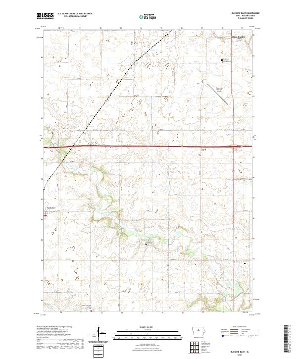
2022 Map of Buckeye East
USGS Topo · Published 2022About this map
The S Fork Iowa River meanders across this Hardin County landscape, defining the rural character of the region south of Iowa Falls. The settlement of Buckeye anchors the western edge of the map, situated amidst a grid of section-line roads such as 200th St and Co Rd D41. This area preserves several localized burial grounds that serve as touchstones for family historians, including the Tipton Norwegian Lutheran Cem and Lincoln Cem. The northern reaches of the quadrangle are influenced by the drainage of Beaver Cr and the presence of the Iowa Falls Municipal Airport, while the south features the secluded Gehrkes Lake. The transition from the river valley to the upland prairies is marked by a network of farm-to-market roads and small, established cemeteries like Cottage Cem, reflecting generations of agricultural continuity in central Iowa.
Find a feature on this map
31 named features on this map. Tap any name to fly to it.
Don’t see what you’re looking for? This feature index may not catch every label — zoom into the map to look around manually.
Map Details
Editions of this 2022 Buckeye East Map
This is the sole edition of this map. No revisions or reprints were ever made.
Other maps of this area

1954 · Waterloo
USGS Topo · 1:250,000

1955 · Waterloo
USGS Topo · 1:250,000

1979 · Iowa Falls West
USGS Topo · 1:24,000

1979 · Buckeye West
USGS Topo · 1:24,000

1979 · Buckeye East
USGS Topo · 1:24,000

1979 · Popejoy
USGS Topo · 1:24,000

1979 · New Providence
USGS Topo · 1:24,000

1979 · Iowa Falls East
USGS Topo · 1:24,000

1979 · Hubbard
USGS Topo · 1:24,000
1979 · Radcliffe
USGS Topo · 1:24,000