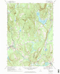
1967 Map of Buckfield
USGS Topo · Published 1969About this map
Nezinscot River drainage systems define the landscape of this Oxford County region in the late 1960s, where the small settlements of Buckfield, East Buckfield, and East Sumner are connected by winding country roads and the distinct West Branch and East Branch watercourses. The area is characterized by a high density of family and community burial grounds, including Hartford Center Cem, Howard Cem, and the Crocker Cem, providing essential primary locations for genealogical research. Prominent high points such as Bear Mountain and Hayford Hill overlook significant water bodies like Bear Pond and the Jersey Bog Brook wetlands. The map details a rural economy centered around the river, evidenced by Chase Mills and various gravel pits, while identifying local landmarks like the High Sch and the Water Tank near the village centers.
Find a feature on this map
62 named features on this map. Tap any name to fly to it.
Don’t see what you’re looking for? This feature index may not catch every label — zoom into the map to look around manually.
Map Details
Editions of this 1967 Buckfield Map
2 editions found
Other maps of this area

1908 · Poland
USGS Topo · 1:62,500

1908 · Lewiston
USGS Topo · 1:62,500

1910 · Livermore
USGS Topo · 1:62,500

1911 · Buckfield
USGS Topo · 1:62,500

1912 · Livermore
USGS Topo · 1:62,500

1913 · Buckfield
USGS Topo · 1:62,500

1940 · Poland
USGS Topo · 1:62,500

1941 · Livermore
USGS Topo · 1:62,500

1942 · Lewiston
USGS Topo · 1:62,500

1942 · Buckfield
USGS Topo · 1:62,500