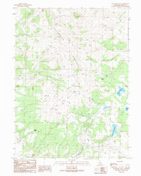
1989 Map of Buckhorn Lake
USGS Topo · Published 1989About this map
The Cottonwood Mountains dominate this high-desert terrain in eastern Lassen County, recorded in the late 1980s. This landscape is defined by its vital water sources and seasonal drainages, which were crucial for the region's ranching and livestock history. High-elevation features like Buckhorn Lake and Willow Lake are central to the topography, while man-made improvements such as Round Corral Reservoir and Powell Reservoir signify the historical management of the arid range. The map reveals a network of natural water points including Gerlach Spring, Gullion Spring, and Bryant Spring, which likely served as stopovers for travelers and stockmen moving through the mountain passes. Below the peaks, the wide opening of Rodeo Flat and the descent of Buckhorn Canyon provide clear evidence of the area's use as grazing land during this period.
Find a feature on this map
13 named features on this map. Tap any name to fly to it.
Don’t see what you’re looking for? This feature index may not catch every label — zoom into the map to look around manually.
Map Details
Editions of this 1989 Buckhorn Lake Map
This is the sole edition of this map. No revisions or reprints were ever made.
Other maps of this area

1886 · Alturas
USGS Topo · 1:250,000

1886 · Honey Lake
USGS Topo · 1:250,000

1886 · Granite Range
USGS Topo · 1:250,000

1889 · Long Valley
USGS Topo · 1:250,000

1891 · Honey Lake
USGS Topo · 1:250,000

1892 · Alturas
USGS Topo · 1:250,000

1893 · Honey Lake
USGS Topo · 1:250,000

1894 · Granite Range
USGS Topo · 1:250,000

1954 · Observation Peak
USGS Topo · 1:62,500

1954 · Vya
USGS Topo · 1:250,000