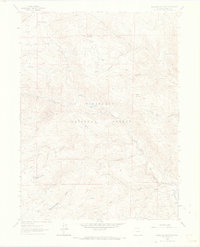
1962 Map of Buckhorn Mountain
USGS Topo · Published 1969About this map
Stove Prairie and the Buckhorn Lodge serve as the primary human outposts in this high-elevation landscape within the Roosevelt National Forest. The map detail reveals a terrain shaped by both historic transport and early resource extraction, notably around Mica Mine Ridge and the nearby Mica Mine Gulch. Movement through the backcountry is defined by a network of historic routes including the Flowers Trail, the Jug Trail, and the Buckhorn High Line.
Find a feature on this map
46 named features on this map. Tap any name to fly to it.
Don’t see what you’re looking for? This feature index may not catch every label — zoom into the map to look around manually.
Map Details
Editions of this 1962 Buckhorn Mountain Map
4 editions found
Other maps of this area

1905 · Mount Olympus
USGS Topo · 1:62,500

1906 · Loveland
USGS Topo · 1:62,500

1906 · Fort Collins
USGS Topo · 1:62,500

1907 · Mount Olympus
USGS Topo · 1:62,500

1907 · Livermore
USGS Topo · 1:125,000

1908 · Loveland
USGS Topo · 1:62,500

1908 · Fort Collins
USGS Topo · 1:62,500

1909 · Livermore
USGS Topo · 1:125,000

1954 · Greeley
USGS Topo · 1:250,000

1957 · Greeley
USGS Topo · 1:250,000