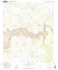
1965 Map of Buckhorn Mountain
USGS Topo · Published 1976About this map
Coconino National Forest defines the rugged geography of this high-country survey, split by the Yavapai Co Coconino Co boundary. The landscape is dominated by significant relief, featuring Buckhorn Mountain and the prominent Sugarloaf peak. Human activity is marked by isolated outposts such as Buckhorn Ranch and the V Lazy Y Cabin, supported by a dense network of upland water catchments including Windmill Tank and Red Hill Tank. The drainage pattern is defined by deep incisions like West Clear Creek and Long North Fork Canyon, which carve through the plateau. A system of historical paths, including the Deadwood Trail and Walker Basin Trail, provides a look at the movement through this high basin before modern infrastructure took hold, centering on the management of livestock and forest resources.
Find a feature on this map
81 named features on this map. Tap any name to fly to it.
Don’t see what you’re looking for? This feature index may not catch every label — zoom into the map to look around manually.
Map Details
Editions of this 1965 Buckhorn Mountain Map
2 editions found
Other maps of this area

1887 · Verde
USGS Topo · 1:250,000

1892 · Verde
USGS Topo · 1:250,000

1923 · Camp Verde
USGS Topo · 1:125,000

1929 · Turret Peak
USGS Topo · 1:125,000

1932 · Camp Verde
USGS Topo · 1:125,000

1933 · Turret Peak
USGS Topo · 1:125,000

1934 · Pine
USGS Topo · 1:62,500

1936 · Camp Verde
USGS Topo · 1:125,000

1940 · Pine
USGS Topo · 1:62,500

1952 · Pine
USGS Topo · 1:62,500