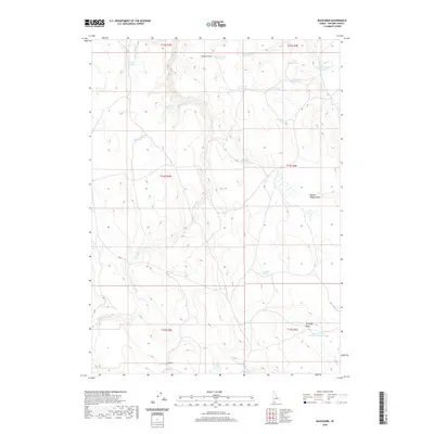
2020 Map of Buckhorn
USGS Topo · Published 2020About this map
Buckhorn sits in the southwestern portion of this high-desert Owyhee County terrain, an area defined by its essential water management features. The landscape is characterized by a network of drainage systems and draws, including the evocatively named Broken Wagon Draw and Timber Draw. For those studying the agricultural and ranching history of southern Idaho, the distribution of water sources is striking, with numerous catchments such as Slate Reservoir, Cinnabar Reservoir, and Two Mile Limit Reservoir serving the livestock and wildlife in this arid environment. Natural springs like Heifer Springs, Bull Spring, and Coyote Pep Spring provide critical watering points across the township lines. The southeastern corner is marked by Antelope Basin, near the Brush Corral Reservoir Number Two, illustrating the necessity of man-made infrastructure to support life and enterprise in this corner of the state.
Find a feature on this map
28 named features on this map. Tap any name to fly to it.
Don’t see what you’re looking for? This feature index may not catch every label — zoom into the map to look around manually.
Map Details
Editions of this 2020 Buckhorn Map
This is the sole edition of this map. No revisions or reprints were ever made.
Other maps of this area

1955 · Jordan Valley
USGS Topo · 1:250,000

1955 · Twin Falls
USGS Topo · 1:250,000

1957 · Jordan Valley
USGS Topo · 1:250,000

1958 · Twin Falls
USGS Topo · 1:250,000

1958 · Jordan Valley
USGS Topo · 1:250,000
1971 · Three Forks
USGS Topo · 1:24,000
1971 · Riddle
USGS Topo · 1:24,000
1972 · Little Blue Table
USGS Topo · 1:24,000
1979 · Antelope Creek
USGS Topo · 1:24,000
1979 · Indian Hay Meadows
USGS Topo · 1:24,000