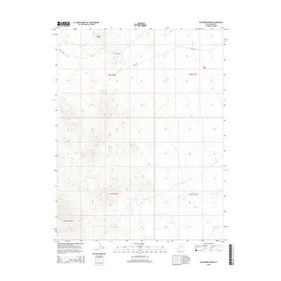
2014 Map of Buckhorn Spring
USGS Topo · Published 2014About this map
The Indian Peak Range dominates the southwestern portion of this Utah landscape, where rugged topography descends into the broad expanse of Pine Valley. Water is the defining resource here, indicated by a series of named water sources that historically supported livestock and wildlife in this arid region, including Buckhorn Spring, Vance Spring, and Meadow Spring. The drainages of Indian Cr and Commissary Cr carve through the southern terrain, while Antelope Wash and Turkey Wash define the central drainage patterns. Human activity is marked primarily by ranching and resource access roads like Vance Spring Rd and Gurneys Rd. This 2014 survey captures a vast section of the Great Basin's high desert, characterized by distinctive landmarks like Elephant Back and the isolated Lower Indian Spring.
Find a feature on this map
18 named features on this map. Tap any name to fly to it.
Don’t see what you’re looking for? This feature index may not catch every label — zoom into the map to look around manually.
Map Details
Editions of this 2014 Buckhorn Spring Map
This is the sole edition of this map. No revisions or reprints were ever made.
Other maps of this area

1953 · Richfield
USGS Topo · 1:250,000

1958 · Richfield
USGS Topo · 1:250,000

1971 · Observation Knoll
USGS Topo · 1:24,000

1971 · Pine Grove Reservoir
USGS Topo · 1:24,000

1971 · Pinto Spring
USGS Topo · 1:24,000

1971 · Sawtooth Peak
USGS Topo · 1:24,000

1971 · Atchison Creek
USGS Topo · 1:24,000

1971 · Lamerdorf Peak NW
USGS Topo · 1:24,000
1972 · Lopers Spring
USGS Topo · 1:24,000
1972 · Buckhorn Spring
USGS Topo · 1:24,000