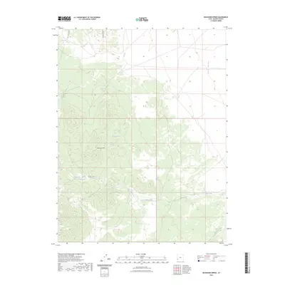
2023 Map of Buckhorn Spring
USGS Topo · Published 2023About this map
The Indian Peak Range dominates this portion of Beaver County, where the high terrain gives way to the broad expanse of Pine Valley to the east. This 2023 survey documents a landscape defined by its vital water sources, including the eponymous Buckhorn Spring and several others such as Meadow Spring and Vance Spring. These isolated springs and the seasonal flows of Indian Creek and Commissary Creek are the primary landmarks in an area shaped by livestock grazing and geological surveying.
Find a feature on this map
11 named features on this map. Tap any name to fly to it.
Don’t see what you’re looking for? This feature index may not catch every label — zoom into the map to look around manually.
Map Details
Editions of this 2023 Buckhorn Spring Map
This is the sole edition of this map. No revisions or reprints were ever made.
Other maps of this area

1953 · Richfield
USGS Topo · 1:250,000

1958 · Richfield
USGS Topo · 1:250,000

1971 · Observation Knoll
USGS Topo · 1:24,000

1971 · Pine Grove Reservoir
USGS Topo · 1:24,000

1971 · Pinto Spring
USGS Topo · 1:24,000

1971 · Sawtooth Peak
USGS Topo · 1:24,000

1971 · Atchison Creek
USGS Topo · 1:24,000

1971 · Lamerdorf Peak NW
USGS Topo · 1:24,000
1972 · Lopers Spring
USGS Topo · 1:24,000
1972 · Buckhorn Spring
USGS Topo · 1:24,000