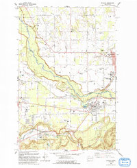
1993 Map of Buckley
USGS Topo · Published 1993About this map
The White River carves a deep valley through the center of this landscape, separating the thriving town of Buckley in Pierce County from Enumclaw and the southern reaches of King County. In the early 1990s, the region retained its agricultural and timber character, evidenced by the broad expanses of Muckleshoot Prairie and Connells Prairie. The map captures an important period of institutional and communal presence, showing the Rainier State School and the Muckleshoot Indian Reservation boundary. Notable for local history is the complex of schools, including White River High Sch and White River Middle Sch, and community landmarks like Finn Hall and the Sunrise Grange. Further south, the town of South Prairie and the settlement of Burnett sit near South Prairie Creek, where an Old RR Grade hints at the area’s industrial rail heritage along the valley floor.
Find a feature on this map
44 named features on this map. Tap any name to fly to it.
Don’t see what you’re looking for? This feature index may not catch every label — zoom into the map to look around manually.
Map Details
Editions of this 1993 Buckley Map
This is the sole edition of this map. No revisions or reprints were ever made.
Other maps of this area

1897 · Tacoma
USGS Topo · 1:125,000

1900 · Tacoma
USGS Topo · 1:125,000

1913 · Cedar Lake
USGS Topo · 1:125,000

1942 · Lake Tapps
USGS Topo · 1:62,500

1944 · Lake Tapps
USGS Topo · 1:62,500

1949 · Black Diamond
USGS Topo · 1:24,000

1949 · Auburn
USGS Topo · 1:24,000

1953 · Cumberland
USGS Topo · 1:24,000

1956 · Orting
USGS Topo · 1:24,000
1956 · Sumner
USGS Topo · 1:24,000