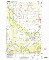
1997 Map of Buckley
USGS Topo · Published 2003About this map
The White River carves a deep valley through this landscape, marking the boundary between King and Pierce counties as it flows past Enumclaw and Buckley. The area is defined by its transition from the plateau-like Muckleshoot Prairie in the north to the industrial and agricultural corridors of the south. Evidence of the region’s timber and transit history is visible in the Old RR Grade and Railroad Grade that parallel South Prairie Creek near South Prairie and Burnett. Cultural landmarks like Finn Hall, Evergreen Memorial Park, and the Muckleshoot Indian Reservation anchor the community's heritage. The presence of the Rainier State School and the Wickersham Basin reflects the evolving land use and infrastructure that supported these foothills settlements during the late 20th century.
Find a feature on this map
64 named features on this map. Tap any name to fly to it.
Don’t see what you’re looking for? This feature index may not catch every label — zoom into the map to look around manually.
Map Details
Editions of this 1997 Buckley Map
This is the sole edition of this map. No revisions or reprints were ever made.
Other maps of this area

1897 · Tacoma
USGS Topo · 1:125,000

1900 · Tacoma
USGS Topo · 1:125,000

1913 · Cedar Lake
USGS Topo · 1:125,000

1942 · Lake Tapps
USGS Topo · 1:62,500

1944 · Lake Tapps
USGS Topo · 1:62,500

1949 · Black Diamond
USGS Topo · 1:24,000

1949 · Auburn
USGS Topo · 1:24,000

1953 · Cumberland
USGS Topo · 1:24,000

1956 · Orting
USGS Topo · 1:24,000
1956 · Sumner
USGS Topo · 1:24,000