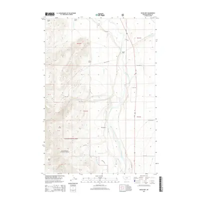
2014 Map of Bucks Nest
USGS Topo · Published 2014About this map
The Madison River valley dominates this portion of Madison County, where the waterway creates a fertile corridor between the high mountain ranges. This 2014 survey captures a landscape defined by ranching and irrigation, evidenced by the intricate network of water management features like Olsen Ditch, Kremer Ditch, and the Hyde Cr Ditch. The presence of the McAtee Bridge provides a critical crossing point for the river, connecting the valley floor to the foothills. To the southwest, the terrain rises sharply into the Beaverhead National Forest, reaching the summit of Bucks Nest. The topography is etched with numerous drainages and family-named landmarks including Johnny Ridge, Sunrise Gulch, and Johny Gulch. This map serves as a detailed record of land use and water rights in a region where the high-altitude environment meets a legacy of homesteading and resource management.
Find a feature on this map
43 named features on this map. Tap any name to fly to it.
Don’t see what you’re looking for? This feature index may not catch every label — zoom into the map to look around manually.
Map Details
Editions of this 2014 Bucks Nest Map
This is the sole edition of this map. No revisions or reprints were ever made.
Other maps of this area

1888 · Three Forks
USGS Topo · 1:250,000

1894 · Three Forks
USGS Topo · 1:250,000

1895 · Three Forks
USGS Topo · 1:250,000

1947 · Bozeman
USGS Topo · 1:250,000

1948 · Bozeman
USGS Topo · 1:250,000

1949 · Varney
USGS Topo · 1:62,500

1950 · Cliff Lake
USGS Topo · 1:62,500

1950 · Cameron
USGS Topo · 1:62,500

1950 · Monument Ridge
USGS Topo · 1:62,500

1955 · Bozeman
USGS Topo · 1:250,000