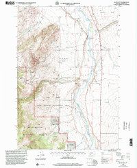
1997 Map of Bucks Nest
USGS Topo · Published 2002About this map
The Madison River corridor and its associated riparian lands are the primary focus of this late-1990s survey, illustrating a landscape managed for both recreation and resource extraction. Significant land tracts are dedicated to conservation, notably the Wall Creek State Wildlife Management Area and the Beaverhead National Forest. This era shows a high level of activity in the hills, from the industrial footprint of the Cyprus Talc Mine near Johnny Gulch to smaller excavations like the Prospect Ruby Mine. Human presence is marked by isolated outposts like the Wall Creek FS Station and Olsen Ranch, while the river itself supports seasonal access via the McAtee Bridge Boat Ramp. The mapping of the Olsen Ditch and Kremer Ditch reveals the critical role of water management in supporting the agricultural potential of the Cameron Bench.
Find a feature on this map
33 named features on this map. Tap any name to fly to it.
Don’t see what you’re looking for? This feature index may not catch every label — zoom into the map to look around manually.
Map Details
Editions of this 1997 Bucks Nest Map
This is the sole edition of this map. No revisions or reprints were ever made.
Other maps of this area

1888 · Three Forks
USGS Topo · 1:250,000

1894 · Three Forks
USGS Topo · 1:250,000

1895 · Three Forks
USGS Topo · 1:250,000

1947 · Bozeman
USGS Topo · 1:250,000

1948 · Bozeman
USGS Topo · 1:250,000

1949 · Varney
USGS Topo · 1:62,500

1950 · Cliff Lake
USGS Topo · 1:62,500

1950 · Cameron
USGS Topo · 1:62,500

1950 · Monument Ridge
USGS Topo · 1:62,500

1955 · Bozeman
USGS Topo · 1:250,000