1982 Map of Bucksport
USGS Topo · Published 1982About this map
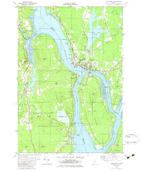
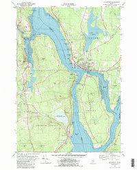
Penobscot River narrows significantly between Prospect and Bucksport, creating a focal point for maritime and industrial activity in the early 1980s. This survey highlights the strategic placement of Fort Knox within Fort Knox State Park, guarding the river approach. On the eastern shore, the town of Bucksport shows a developed waterfront featuring industrial waste ponds and a boat ramp, reflecting its history as a manufacturing hub.
Find a feature on this map
65 named features on this map. Tap any name to fly to it.
Don’t see what you’re looking for? This feature index may not catch every label — zoom into the map to look around manually.
Map Details
Editions of this 1982 Bucksport Map
2 editions found
Other maps of this area

1900 · Orland
USGS Topo · 1:62,500

1900 · Bucksport
USGS Topo · 1:62,500

1902 · Bucksport
USGS Topo · 1:62,500

1902 · Castine
USGS Topo · 1:62,500

1904 · Castine
USGS Topo · 1:62,500

1904 · Bluehill
USGS Topo · 1:62,500

1905 · Penobscot Bay
USGS Topo · 1:125,000
1941 · Castine
USGS Topo · 1:62,500

1942 · Orland
USGS Topo · 1:62,500

1942 · Bucksport
USGS Topo · 1:62,500