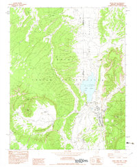
1982 Map of Buell Park
USGS Topo · Published 1983About this map
The Navajo Indian Reservation spans the boundary between Arizona and New Mexico in this early 1980s provisional survey, centering on the circular volcanic depression of Buell Park. This unique geological feature is flanked by prominent landmarks like Buell Mtn and Sterrett Mesa. The settlement of Navajo sits near the base of the Chuska Mountains, serving as a focal point for the region's infrastructure alongside the Red Lake Chapter House.
Find a feature on this map
21 named features on this map. Tap any name to fly to it.
Don’t see what you’re looking for? This feature index may not catch every label — zoom into the map to look around manually.
Map Details
Editions of this 1982 Buell Park Map
This is the sole edition of this map. No revisions or reprints were ever made.
Other maps of this area

1886 · Wingate
USGS Topo · 1:250,000

1886 · Fort Defiance
USGS Topo · 1:250,000

1889 · Chaco
USGS Topo · 1:250,000

1892 · Fort Defiance
USGS Topo · 1:250,000

1892 · Wingate
USGS Topo · 1:250,000

1892 · Chaco
USGS Topo · 1:250,000

1892 · Canyon De Chelly
USGS Topo · 1:250,000

1954 · Shiprock
USGS Topo · 1:250,000

1954 · Gallup
USGS Topo · 1:250,000

1955 · Zith-Tusayan Butte 1 SE
USGS Topo · 1:24,000