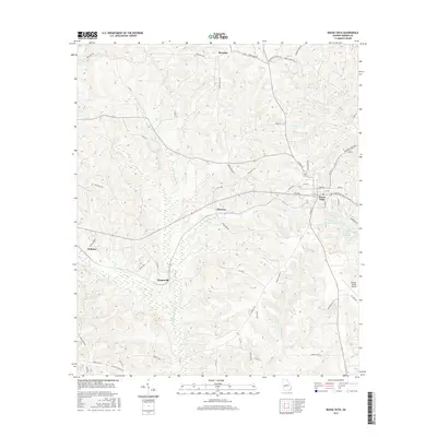
2017 Map of Buena Vista
USGS Topo · Published 2017About this map
Buena Vista serves as the focal point of this Marion County landscape, showing its organized street grid and proximity to the Marion County Airport. To the west and north, smaller rural nodes like Brantley, Elmview, Berginville, and Zellobee mark the intersections of a network of county roads, including Brantley Rd and Pineville Rd. The terrain is defined by its complex drainage systems, where the winding Kinchafoonee Cr and Lanahassee Cr carve through the countryside.
Find a feature on this map
58 named features on this map. Tap any name to fly to it.
Don’t see what you’re looking for? This feature index may not catch every label — zoom into the map to look around manually.
Map Details
Editions of this 2017 Buena Vista Map
This is the sole edition of this map. No revisions or reprints were ever made.
Other maps of this area

1949 · Glen Alta
USGS Topo · 1:24,000

1949 · Buena Vista NW
USGS Topo · 1:24,000

1950 · Buena Vista NE
USGS Topo · 1:24,000

1950 · Buena Vista
USGS Topo · 1:24,000

1950 · Buena Vista
USGS Topo · 1:62,500
1955 · Buena Vista NW
USGS Topo · 1:24,000

1955 · Buena Vista
USGS Topo · 1:24,000

1955 · Buena Vista NE
USGS Topo · 1:24,000
1955 · Glen Alta
USGS Topo · 1:24,000
1955 · Buena Vista
USGS Topo · 1:62,500