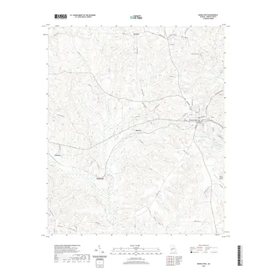
2020 Map of Buena Vista
USGS Topo · Published 2020About this map
The Marion County Courthouse serves as the focal point of Buena Vista, anchoring a network of roads that radiate through the central Georgia landscape. This area is defined by its numerous small communities and family-named routes, such as Brantley to the north and Elmview situated along the Peacock Ditch. The drainage patterns of Kinchafoonee Cr and Lanahassee Cr carve through the terrain, illustrating the intricate hydrology of the region. Local landmarks like the Marion County Airport and recreational areas including Walker Williams Lakes and Bebolu Lake highlight the mix of civic infrastructure and natural water features. Smaller settlements like Berginville and Zellobee remain connected by rural corridors such as Pineville Rd and Brantley Rd, preserving the traditional layout of the county.
Find a feature on this map
63 named features on this map. Tap any name to fly to it.
Don’t see what you’re looking for? This feature index may not catch every label — zoom into the map to look around manually.
Map Details
Editions of this 2020 Buena Vista Map
This is the sole edition of this map. No revisions or reprints were ever made.
Other maps of this area

1949 · Glen Alta
USGS Topo · 1:24,000

1949 · Buena Vista NW
USGS Topo · 1:24,000

1950 · Buena Vista NE
USGS Topo · 1:24,000

1950 · Buena Vista
USGS Topo · 1:24,000

1950 · Buena Vista
USGS Topo · 1:62,500
1955 · Buena Vista NW
USGS Topo · 1:24,000

1955 · Buena Vista
USGS Topo · 1:24,000

1955 · Buena Vista NE
USGS Topo · 1:24,000
1955 · Glen Alta
USGS Topo · 1:24,000
1955 · Buena Vista
USGS Topo · 1:62,500