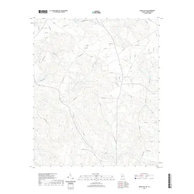
2020 Map of Buena Vista NE
USGS Topo · Published 2020About this map
Kinchafoonee Cr and its various tributaries carve a complex drainage pattern through this section of Marion County, Georgia. The landscape is defined by its rural road network, where family and local history are etched into the names of thoroughfares like Palmer Cemetery Rd and Palmer Cemetery Rd. The terrain is characterized by numerous small creeks, including Little Juniper Cr, Parkers Mill Cr, and Little Cr, which once supported local milling operations and early water access. These watercourses converge toward larger features such as Heards Lakes and Melton Lake in the southern reaches of the quadrangle. In the northern section, local life centers around the Bethany Loop area and the rural corridor along Oakland Rd. The abundance of ford and mill references in the hydronyms, such as Hordage Ford Cr, points to a long history of traditional river crossings and localized industry.
Find a feature on this map
62 named features on this map. Tap any name to fly to it.
Don’t see what you’re looking for? This feature index may not catch every label — zoom into the map to look around manually.
Map Details
Editions of this 2020 Buena Vista NE Map
This is the sole edition of this map. No revisions or reprints were ever made.
Other maps of this area

1907 · Talbotton
USGS Topo · 1:125,000

1949 · Glen Alta
USGS Topo · 1:24,000

1949 · Upatoi
USGS Topo · 1:24,000

1949 · Buena Vista NW
USGS Topo · 1:24,000

1950 · Geneva
USGS Topo · 1:24,000

1950 · Buena Vista NE
USGS Topo · 1:24,000

1950 · Buena Vista
USGS Topo · 1:24,000

1950 · Buena Vista
USGS Topo · 1:62,500

1950 · Talbotton
USGS Topo · 1:62,500
1955 · Buena Vista NW
USGS Topo · 1:24,000