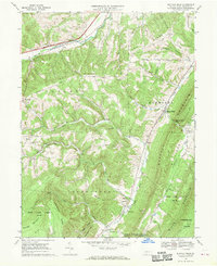
1967 Map of Buffalo Mills
USGS Topo · Published 1970About this map
Buffalo Mills and the surrounding valley in Bedford County are defined by the convergence of steep Appalachian ridges and active transportation corridors. During the late 1960s, the Penn Central railroad and the Pennsylvania Turnpike carved through the landscape, bypassing smaller settlements like Kegg, Madley, and West End. The map reveals a deeply established rural community, evidenced by the numerous local houses of worship and burying grounds such as St James Cem, Lybarger Ch, and Pleasant Ridge Ch. These cultural landmarks are often found nestled in the gaps between massive landforms like Buffalo Mountain and Wills Mountain. Significant portions of the territory are dedicated to conservation and recreation, including State Game Lands No 48 and State Game Lands No 104, while localized industries are represented by a Gravel Pit near the southern boundary.
Find a feature on this map
48 named features on this map. Tap any name to fly to it.
Don’t see what you’re looking for? This feature index may not catch every label — zoom into the map to look around manually.
Map Details
Editions of this 1967 Buffalo Mills Map
Other maps of this area

1908 · Bedford
USGS Topo · 1:62,500

1910 · Bedford
USGS Topo · 1:62,500

1914 · Windber
USGS Topo · 1:62,500

1916 · Windber
USGS Topo · 1:62,500

1923 · Berlin
USGS Topo · 1:48,000

1927 · Hyndman
USGS Topo · 1:62,500

1929 · Berlin
USGS Topo · 1:62,500

1931 · Hyndman
USGS Topo · 1:62,500

1944 · Hyndman
USGS Topo · 1:62,500

1944 · Windber
USGS Topo · 1:62,500
Featured Places
- Cumberland Valley Township, PA
- Harrison Township, PA
- Madley, Londonderry Township
- Buffalo Mills, Harrison Township
- Kegg, Juniata Township