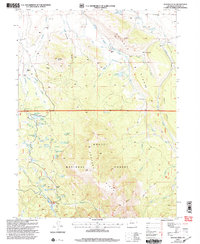
2000 Map of Buffalo Peak
USGS Topo · Published 2004About this map
Buffalo Peak and the surrounding high-country watersheds define this landscape within the Routt National Forest and Arapaho National Forest. The map documents a sophisticated network of high-altitude water management, where numerous ditches such as the Slack-Weiss Ditch No 2, Van Patten Ditch, and West Buffalo Ditch divert flows across Buffalo Ridge to serve various reservoirs. This water system supports several named ranching outposts on the northern slopes, including Buffalo Ranch, Shamrock Ranch, and Wheatley Ranch. South of the ridge, the terrain is dotted with alpine water bodies like the Arapaho Lakes, Willow Lake, and Deep Lake, many of which are accessible only by the 4wd tracks that represent the primary transportation network through the timbered heights and open meadows of Bundy Park.
Find a feature on this map
60 named features on this map. Tap any name to fly to it.
Don’t see what you’re looking for? This feature index may not catch every label — zoom into the map to look around manually.
Map Details
Editions of this 2000 Buffalo Peak Map
This is the sole edition of this map. No revisions or reprints were ever made.
Other maps of this area

1954 · Craig
USGS Topo · 1:250,000

1955 · Coalmont
USGS Topo · 1:24,000

1955 · Owl Ridge
USGS Topo · 1:24,000

1955 · Mac Farlane Reservoir
USGS Topo · 1:24,000

1955 · Walden
USGS Topo · 1:62,500

1956 · Spicer Peak
USGS Topo · 1:24,000

1956 · Parkview Mountain
USGS Topo · 1:24,000

1956 · Buffalo Peak
USGS Topo · 1:24,000

1956 · Whiteley Peak
USGS Topo · 1:24,000

1956 · Hyannis Peak
USGS Topo · 1:24,000