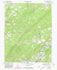
1969 Map of Buffalo Ridge
USGS Topo · Published 1981About this map
Buffalo Ridge dominates the center of this Virginia landscape, where the Tye River and James River define the northern and southern boundaries. The terrain reflects a transition from high ridges to fertile river bottoms, connected by the paths of the Southern RR near New Glasgow and the Chesapeake and Ohio RR winding along the James. This 1980 revision shows the enduring rural character of the region, anchored by community landmarks such as Wesleyan Ch, Galilee Ch, and St James Ch. Local history is preserved in the location of numerous small cemeteries and the site of Walkers Ford, a crossing point on the James. The map also traces the industrial and recreational features of the era, from a hilltop Lookout Tower on Larkin Mountain to the Gaging Sta at Piedmont, illustrating how the land was managed and monitored.
Find a feature on this map
32 named features on this map. Tap any name to fly to it.
Don’t see what you’re looking for? This feature index may not catch every label — zoom into the map to look around manually.
Map Details
Editions of this 1969 Buffalo Ridge Map
2 editions found
Other maps of this area

1892 · Lynchburg
USGS Topo · 1:125,000

1892 · Buckingham
USGS Topo · 1:125,000

1892 · Appomattox
USGS Topo · 1:125,000

1894 · Lexington
USGS Topo · 1:125,000

1935 · Amherst
USGS Topo · 1:48,000

1939 · Amherst
USGS Topo · 1:62,500

1944 · Lynchburg
USGS Topo · 1:62,500

1947 · Roanoke
USGS Topo · 1:250,000

1950 · Amherst
USGS Topo · 1:62,500

1950 · Lynchburg
USGS Topo · 1:62,500