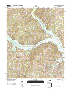
2013 Map of Buffalo Springs
USGS Topo · Published 2013About this map
The confluence of the Dan River and Hyco River defines this landscape in southern Virginia, where the waters broaden into the western reaches of the John H. Kerr Reservoir. Historically significant rural hubs like Dryburg and Buffalo Springs sit along a network of roads that reflect generations of settlement, including Tabernacle Rd and Gravel Hill Rd. Small-scale infrastructure and aviation history are evident at the Aaron Penston Field Airport near Aarons Creek.
Find a feature on this map
93 named features on this map. Tap any name to fly to it.
Don’t see what you’re looking for? This feature index may not catch every label — zoom into the map to look around manually.
Map Details
Editions of this 2013 Buffalo Springs Map
This is the sole edition of this map. No revisions or reprints were ever made.
Other maps of this area

1941 · Clarksville
USGS Topo · 1:48,000

1943 · Clarksville
USGS Topo · 1:62,500

1953 · South Boston
USGS Topo · 1:62,500

1953 · Greensboro
USGS Topo · 1:250,000

1954 · Greensboro
USGS Topo · 1:250,000

1954 · Clover
USGS Topo · 1:62,500

1954 · Halifax
USGS Topo · 1:62,500

1957 · South Boston
USGS Topo · 1:62,500

1957 · Clarksville
USGS Topo · 1:62,500

1962 · Greensboro
USGS Topo · 1:250,000