
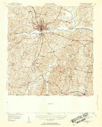
1953 Map of South Boston
USGS Topo · Published 1955About this map
The Dan River and Banister River converge in this mid-century portrait of southern Halifax County, centered on the hub of South Boston. The landscape reveals a complex transportation network where the Norfolk and Western Railway, Southern Railway, and Atlantic and Danville Railway intersect, supporting the region's agricultural and industrial base. Near the North Carolina border, the settlement of Virgilina serves as a southern anchor, while rural life is marked by numerous country institutions such as Dan River Ch, Ebenezer Ch, and Orange Grove Sch.
Find a feature on this map
69 named features on this map. Tap any name to fly to it.
Don’t see what you’re looking for? This feature index may not catch every label — zoom into the map to look around manually.
Map Details
Editions of this 1953 South Boston Map
2 editions found
Other maps of this area

1941 · Clarksville
USGS Topo · 1:48,000

1943 · Clarksville
USGS Topo · 1:62,500

1943 · Roxboro
USGS Topo · 1:62,500

1952 · Milton
USGS Topo · 1:62,500

1953 · Oxford
USGS Topo · 1:62,500

1953 · Greensboro
USGS Topo · 1:250,000

1954 · Greensboro
USGS Topo · 1:250,000

1954 · Clover
USGS Topo · 1:62,500

1954 · Halifax
USGS Topo · 1:62,500

1954 · Riceville
USGS Topo · 1:62,500