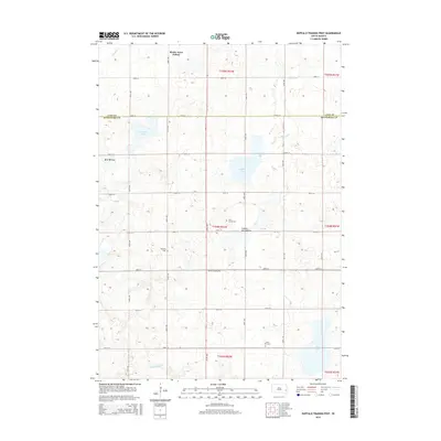
2015 Map of Buffalo Trading Post
USGS Topo · Published 2015About this map
Coteau des Prairies defines the rolling, water-dotted topography of this South Dakota landscape, where the boundary between Lake and Minnehaha counties meets. The area is characterized by a high density of glacial lakes and depressions, including Diamond Lake and the expansive Buffalo Lake. Human settlement is anchored by the Rustic Acres Colony to the north and the namesake Buffalo Trading Post situated centrally along the section lines. Genealogical researchers will find several well-defined burial sites across the townships, such as Saint Jacobs Cem and Bethany Cem near the western edge, and Clear Lake Cem overlooking the waters of Clear Lake in the south. The drainage network is dictated by the slow-moving waters of Buffalo Cr and the W Br Skunk Cr, which weave through a strictly partitioned grid of agricultural section roads.
Find a feature on this map
33 named features on this map. Tap any name to fly to it.
Don’t see what you’re looking for? This feature index may not catch every label — zoom into the map to look around manually.
Map Details
Editions of this 2015 Buffalo Trading Post Map
This is the sole edition of this map. No revisions or reprints were ever made.
Other maps of this area

1955 · Sioux Falls
USGS Topo · 1:250,000

1958 · Sioux Falls
USGS Topo · 1:250,000

1962 · Hartford North
USGS Topo · 1:24,000

1964 · Montrose
USGS Topo · 1:24,000

1964 · Humboldt
USGS Topo · 1:24,000

1968 · Lake Madison
USGS Topo · 1:24,000

1968 · Wentworth
USGS Topo · 1:24,000
1968 · Colton
USGS Topo · 1:24,000
1968 · Buffalo Trading Post
USGS Topo · 1:24,000

1968 · Lake Madison SW
USGS Topo · 1:24,000
Featured Places
- Clear Lake Township, SD
- Franklin Township, SD
- Chester Township, SD
- Taopi Township, SD
- Grand Meadow Township, SD