
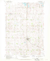
1968 Map of Wentworth
USGS Topo · Published 1970About this map
Wentworth and Chester anchor this late-1960s landscape in eastern South Dakota, where the rail-and-water geography of Lake County is on full display. The northern section of the map is dominated by the Chicago Milwaukee St Paul and Pacific line, while the Great Northern railroad bisects the southern townships. Water defines the local character, from the sprawling Brant Lake and Lake Madison to the protected wetlands of the Buffalo Slough State Game Refuge.
Find a feature on this map
30 named features on this map. Tap any name to fly to it.
Don’t see what you’re looking for? This feature index may not catch every label — zoom into the map to look around manually.
Map Details
Editions of this 1968 Wentworth Map
This is the sole edition of this map. No revisions or reprints were ever made.
Other maps of this area

1953 · Watertown
USGS Topo · 1:250,000

1955 · Sioux Falls
USGS Topo · 1:250,000

1958 · Sioux Falls
USGS Topo · 1:250,000

1958 · Watertown
USGS Topo · 1:250,000

1962 · Colton SE
USGS Topo · 1:24,000

1963 · Colman
USGS Topo · 1:24,000

1964 · Rutland SE
USGS Topo · 1:24,000

1968 · Lake Madison
USGS Topo · 1:24,000

1968 · Madison
USGS Topo · 1:24,000
1968 · Colton
USGS Topo · 1:24,000