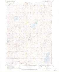
1968 Map of Buffalo Trading Post
USGS Topo · Published 1970About this map
Buffalo Trading Post serves as a central landmark in this prairie landscape along the border of Lake and Minnehaha counties. The terrain is defined by a series of kettle lakes and depressions, including Diamond Lake, Buffalo Lake, and Island Lake, which are characteristic of the region's glacial history. Cultural and community life of the late 1960s is reflected in the placement of rural landmarks such as St Jacobs Ch and its associated St Jacobs Cem, alongside Bethany Cem and Clear Lake Cem.
Find a feature on this map
20 named features on this map. Tap any name to fly to it.
Don’t see what you’re looking for? This feature index may not catch every label — zoom into the map to look around manually.
Map Details
Editions of this 1968 Buffalo Trading Post Map
This is the sole edition of this map. No revisions or reprints were ever made.
Other maps of this area

1955 · Sioux Falls
USGS Topo · 1:250,000

1958 · Sioux Falls
USGS Topo · 1:250,000

1962 · Hartford North
USGS Topo · 1:24,000

1964 · Montrose
USGS Topo · 1:24,000

1964 · Humboldt
USGS Topo · 1:24,000

1968 · Lake Madison
USGS Topo · 1:24,000

1968 · Wentworth
USGS Topo · 1:24,000
1968 · Colton
USGS Topo · 1:24,000

1968 · Lake Madison SW
USGS Topo · 1:24,000

1968 · Lake Herman
USGS Topo · 1:24,000
Featured Places
- Rustic Acres Hutterite Colony, SD
- Chester Township, SD
- Grand Meadow Township, SD
- Franklin Township, SD
- Buffalo Township, SD