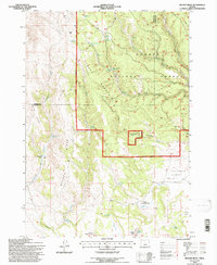
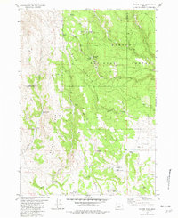
1992 Map of Bulger Ridge
USGS Topo · Published 1997About this map
Ochogo National Forest dominates the high desert landscape of this 1990s revision, where the Snow Mountain Ranger District meets the open rangelands of Harney and Crook counties. The map details a sophisticated network of upland water management, essential for ranching and forest operations, featuring numerous named catchments such as Spencer Reservoir, Pats Reservoir, and the Swamp Creek Reservoir. Evidence of early and contemporary land use is visible at the Juniper Hill Ranch, positioned near the western edge of the prominent Bulger Ridge. The terrain transitions from the high peaks of Buck Mountain down to the broad expanse of Ryegrass Flat and Mud Flat. This survey captures the region's character as a working forest and livestock range, defined by isolated springs like Bulger Spring and seasonal water sources such as Spencers Waterhole and North Sheep Lake.
Find a feature on this map
42 named features on this map. Tap any name to fly to it.
Don’t see what you’re looking for? This feature index may not catch every label — zoom into the map to look around manually.
Map Details
Editions of this 1992 Bulger Ridge Map
This is the sole edition of this map. No revisions or reprints were ever made.
Other maps of this area

1955 · Burns
USGS Topo · 1:250,000

1958 · Burns
USGS Topo · 1:250,000

1959 · Burns
USGS Topo · 1:250,000

1961 · Delintment Lake
USGS Topo · 1:62,500

1981 · Hat Butte
USGS Topo · 1:24,000
1981 · Mackey Butte
USGS Topo · 1:24,000
1981 · Potato Hills
USGS Topo · 1:24,000
1981 · Dust Bowl
USGS Topo · 1:24,000
1981 · Bulger Ridge
USGS Topo · 1:24,000

1981 · Camp Currey Spring
USGS Topo · 1:24,000