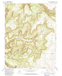
1994 Map of Bull Canyon
USGS Topo · Published 1994About this map
Uranium Radium Department of Energy Reserve land dominates this high-mesa landscape, reflecting the intensive mineral extraction history along the Montrose and San Miguel County line. The map reveals an intricate network of specialized extraction sites, including the Monogram Mine, Wedding Bell Mine, and Joe Dandy Mine, all linked by precarious 4wd routes. Significant local history is preserved at the Indian Henrys Cabin and the Bachelor Camp (Site), suggesting a rugged era of prospectors and miners. The terrain is defined by dramatic plateaus such as Skein Mesa and Monogram Mesa, which drop into the carved depths of Bull Canyon. These geological features necessitated the creation of upland water sources like the Monogram Mesa Reservoir to support the industrial activity and seasonal camps found throughout the drainage systems of Wild Horse Draw and Bachelor Draw.
Find a feature on this map
63 named features on this map. Tap any name to fly to it.
Don’t see what you’re looking for? This feature index may not catch every label — zoom into the map to look around manually.
Map Details
Editions of this 1994 Bull Canyon Map
This is the sole edition of this map. No revisions or reprints were ever made.
Other maps of this area

1916 · Paradox Valley
USGS Topo · 1:125,000

1922 · Paradox Valley
USGS Topo · 1:125,000

1948 · Bull Canyon
USGS Topo · 1:24,000

1948 · Horse Range Mesa
USGS Topo · 1:24,000

1948 · Uravan
USGS Topo · 1:24,000

1948 · Hamm Canyon
USGS Topo · 1:24,000

1948 · Naturita NW
USGS Topo · 1:24,000

1948 · Paradox
USGS Topo · 1:24,000

1948 · Gypsum Gap
USGS Topo · 1:24,000

1949 · Bull Canyon
USGS Topo · 1:24,000