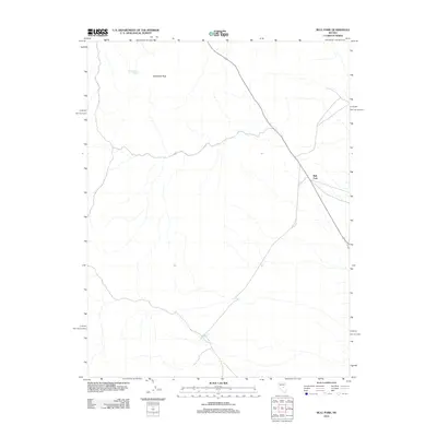
2012 Map of Bull Fork
USGS Topo · Published 2012About this map
Duckwater Peak anchors this corner of the Nevada landscape, overlooking a series of water sources that supported travelers and ranchers in this arid region. The presence of Butte Station Spring in the north and Big Louie Spring in the south points to the historical importance of localized water points for movement through the high desert. The terrain is bisected by the diagonal route of State Route 379, which passes through the Bull Fork valley. This 2012 survey shows the sparse, functional layout of the modern Nye County interior, where natural landmarks and critical springs remain the primary waypoints in an otherwise open topography.
Find a feature on this map
5 named features on this map. Tap any name to fly to it.
Don’t see what you’re looking for? This feature index may not catch every label — zoom into the map to look around manually.
Map Details
Editions of this 2012 Bull Fork Map
This is the sole edition of this map. No revisions or reprints were ever made.
Other maps of this area

1951 · Green Springs
USGS Topo · 1:62,500

1956 · Lund
USGS Topo · 1:250,000

1956 · Ely
USGS Topo · 1:250,000

1959 · Ely
USGS Topo · 1:250,000

1960 · Lund
USGS Topo · 1:250,000

1963 · Ely
USGS Topo · 1:250,000

1964 · Duckwater
USGS Topo · 1:62,500

1964 · Moody Peak
USGS Topo · 1:62,500

1968 · Brown Summit
USGS Topo · 1:24,000
1968 · Brown Summit NW
USGS Topo · 1:24,000