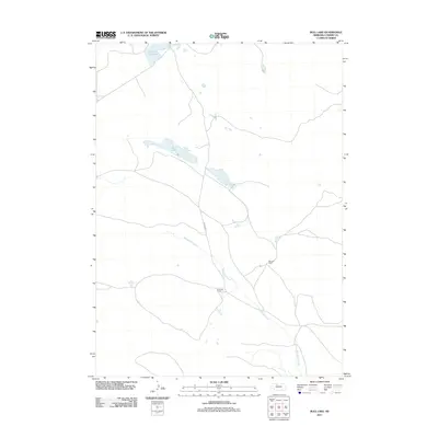
2011 Map of Bull Lake
USGS Topo · Published 2011About this map
Wamaduze Creek winds through this expanse of Cherry County, defining the drainage patterns of a landscape characterized by isolated cattle operations and scattered water bodies. The presence of McLeod Ranch and S Hanna Ranch reflects the enduring pastoral economy of the Nebraska Sandhills, where large landholdings are necessary to support ranching. These named homesteads serve as significant landmarks in an area with few formal settlements. Water resources are concentrated at Bull Lake and Lone Tree Lake, which provide essential catchments for livestock. The primary transit corridor is Brownlee Rd, which connects these remote outposts across the prairie, illustrating the sparse infrastructure and specialized land use of this region in the early 21st century.
Find a feature on this map
6 named features on this map. Tap any name to fly to it.
Don’t see what you’re looking for? This feature index may not catch every label — zoom into the map to look around manually.
Map Details
Editions of this 2011 Bull Lake Map
This is the sole edition of this map. No revisions or reprints were ever made.
Other maps of this area

1950 · Simeon
USGS Topo · 1:62,500

1950 · Kennedy
USGS Topo · 1:62,500

1951 · Bull Lake
USGS Topo · 1:62,500

1951 · Brownlee
USGS Topo · 1:62,500

1957 · Valentine
USGS Topo · 1:250,000

1959 · Valentine
USGS Topo · 1:250,000

1985 · Goose Creek
USGS Topo · 1:100,000
1985 · Windmill Lake
USGS Topo · 1:24,000

1985 · Valentine
USGS Topo · 1:100,000
1985 · Kennedy
USGS Topo · 1:24,000