
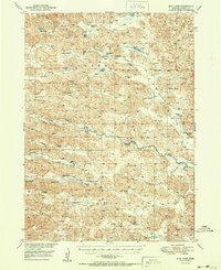
1951 Map of Bull Lake
USGS Topo · Published 1951About this map
Sears Ranch and Kidder Ranch anchor this mid-century view of the Nebraska Sandhills, a landscape defined by an intricate network of lakes, meadows, and seasonal wetlands. The North Loup River winds through the center of the sheet, where a crossing at the Hatters Bridge is already noted as out of use. The cattle economy of the 1940s and early 1950s is evident in the numerous family-named properties, such as the Murphy Ranch and McCloud Ranch, which are interspersed with essential local infrastructure like School No 113 and the Sears Sch. The survey captures a high-water table era, documenting numerous named water bodies including Stout Lake, Mud Lake, and the expansive Bull Lake. These features, along with Murphy Swamp, illustrate the complex hydrology of Cherry County before modern agricultural changes altered many of these smaller basins.
Find a feature on this map
41 named features on this map. Tap any name to fly to it.
Don’t see what you’re looking for? This feature index may not catch every label — zoom into the map to look around manually.
Map Details
Editions of this 1951 Bull Lake Map
2 editions found
Other maps of this area

1948 · Seneca
USGS Topo · 1:62,500

1948 · Mullen
USGS Topo · 1:62,500

1948 · Seneca 4
USGS Topo · 1:62,500

1949 · Seneca 4
USGS Topo · 1:62,500

1949 · Big Falls
USGS Topo · 1:62,500

1950 · Simeon
USGS Topo · 1:62,500

1950 · Powderhorn Valley
USGS Topo · 1:62,500

1950 · Kennedy
USGS Topo · 1:62,500

1951 · Mullen
USGS Topo · 1:62,500

1951 · Seneca
USGS Topo · 1:62,500