
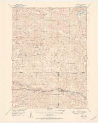
1951 Map of Seneca
USGS Topo · Published 1951About this map
The Middle Loup River winds through the southern portion of this Nebraska Sandhills landscape, creating a narrow corridor of valley floor between the extensive dune terrain. The village of Seneca serves as the primary hub along the Chicago Burlington and Quincy railroad, which follows the river's path. This mid-century survey illustrates a ranching economy defined by family-named holdings scattered across the hills, such as the Simonson and Lowe Ranch and Phillips Ranch. Local social infrastructure is visible through the remote Virginia Sch and Huddle Sch, while the James Cem provides a genealogical touchpoint for early settlers. The northern reaches are characterized by numerous small basins and water bodies including Swan Lake and Conway Lake, which contrast with the higher elevations of Giant Hill and the dry expanses of Dry Valley.
Find a feature on this map
41 named features on this map. Tap any name to fly to it.
Don’t see what you’re looking for? This feature index may not catch every label — zoom into the map to look around manually.
Map Details
Editions of this 1951 Seneca Map
2 editions found
Other maps of this area

1947 · Dismal River Ranch
USGS Topo · 1:62,500

1948 · Seneca
USGS Topo · 1:62,500

1948 · Thedford
USGS Topo · 1:62,500

1948 · Mullen
USGS Topo · 1:62,500

1948 · Seneca 4
USGS Topo · 1:62,500

1949 · Seneca 4
USGS Topo · 1:62,500

1949 · Dismal River Ranch
USGS Topo · 1:62,500

1949 · Big Falls
USGS Topo · 1:62,500

1950 · Thedford
USGS Topo · 1:62,500

1950 · Shimmins Lake
USGS Topo · 1:62,500