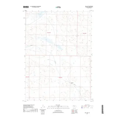
2017 Map of Bull Lake
USGS Topo · Published 2017About this map
Bull Lake and its surrounding wetlands define this portion of the Nebraska Sandhills, a landscape of low drainage and subtle topography. The map centers on a series of small, isolated basins including Lone Tree Lake, Packingham Lake, and Stub Lake, which characterize the region's hydrography. The terrain is marked by the Wamaduze Valley, where the waters of Wamaduze Cr flow toward the southeast. This 2017 survey reflects the sparse settlement patterns and ranching infrastructure typical of Cherry County, with Brownlee Rd providing the primary thoroughfare through the township boundaries of T29N R30W and T28N R30W.
Find a feature on this map
11 named features on this map. Tap any name to fly to it.
Don’t see what you’re looking for? This feature index may not catch every label — zoom into the map to look around manually.
Map Details
Editions of this 2017 Bull Lake Map
This is the sole edition of this map. No revisions or reprints were ever made.
Other maps of this area

1950 · Simeon
USGS Topo · 1:62,500

1950 · Kennedy
USGS Topo · 1:62,500

1951 · Bull Lake
USGS Topo · 1:62,500

1951 · Brownlee
USGS Topo · 1:62,500

1957 · Valentine
USGS Topo · 1:250,000

1959 · Valentine
USGS Topo · 1:250,000

1985 · Goose Creek
USGS Topo · 1:100,000
1985 · Windmill Lake
USGS Topo · 1:24,000

1985 · Valentine
USGS Topo · 1:100,000
1985 · Kennedy
USGS Topo · 1:24,000