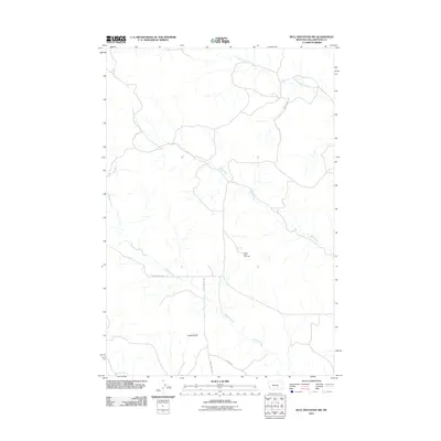
2011 Map of Bull Mountain NW
USGS Topo · Published 2011About this map
Castle Butte rises above the drainage networks of south-central Montana, anchoring a landscape defined by its high-country watercourses and rural thoroughfares. This 2011 survey illustrates a sparsely populated section of Yellowstone County where cattle ranching and open-range land use dictate the layout of the land. Water management is central to the area's geography, with the branching systems of Hibbard Creek, Mill Creek, and Antelope Creek carving into the terrain. Cultural history is centered at the Castle Butte Cemetery, a primary landmark for local genealogy and regional history. The map traces the essential road network that connects these remote points, including Hibbard Creek Rd and Castle Butte Rd, providing a clear record of the intersection between physical geography and the enduring infrastructure of the Montana interior.
Find a feature on this map
9 named features on this map. Tap any name to fly to it.
Don’t see what you’re looking for? This feature index may not catch every label — zoom into the map to look around manually.
Map Details
Editions of this 2011 Bull Mountain NW Map
This is the sole edition of this map. No revisions or reprints were ever made.
Other maps of this area

1954 · Forsyth
USGS Topo · 1:250,000

1954 · Roundup
USGS Topo · 1:250,000

1957 · Forsyth
USGS Topo · 1:250,000

1958 · Roundup
USGS Topo · 1:250,000

1958 · Forsyth
USGS Topo · 1:250,000
1967 · Big Marys Island
USGS Topo · 1:24,000
1967 · Bull Mountain
USGS Topo · 1:24,000

1979 · Roundup
USGS Topo · 1:100,000

1979 · Hysham
USGS Topo · 1:100,000

1980 · Mud Butte
USGS Topo · 1:24,000