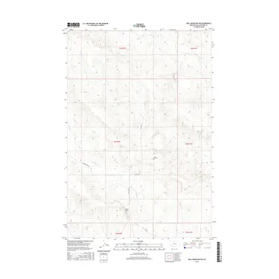
2017 Map of Bull Mountain NW
USGS Topo · Published 2017About this map
Castle Butte rises above the headwaters and drainage basins of central Montana in this 2017 survey, serving as a focal point for the surrounding local infrastructure. The landscape is defined by the carved paths of Antelope Cr, Mill Cr, and Hibbard Cr, which dictate the placement of rural corridors. Modern access is maintained through a network of roads including Pineview Rd and Castle Butte Rd, providing a clear view of how high-plains topography influences local transit. Genealogists and local historians will find value in the location of the Castle Butte Cem, situated near the eponymous butte, while the various township and range lines, such as t6n r30e and t5n r31e, offer a precise framework for tracing historical land tracts and family property in this part of Yellowstone County.
Find a feature on this map
15 named features on this map. Tap any name to fly to it.
Don’t see what you’re looking for? This feature index may not catch every label — zoom into the map to look around manually.
Map Details
Editions of this 2017 Bull Mountain NW Map
This is the sole edition of this map. No revisions or reprints were ever made.
Other maps of this area

1954 · Forsyth
USGS Topo · 1:250,000

1954 · Roundup
USGS Topo · 1:250,000

1957 · Forsyth
USGS Topo · 1:250,000

1958 · Roundup
USGS Topo · 1:250,000

1958 · Forsyth
USGS Topo · 1:250,000
1967 · Big Marys Island
USGS Topo · 1:24,000
1967 · Bull Mountain
USGS Topo · 1:24,000

1979 · Roundup
USGS Topo · 1:100,000

1979 · Hysham
USGS Topo · 1:100,000

1980 · Mud Butte
USGS Topo · 1:24,000