
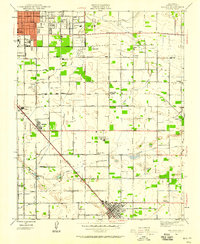
1923 Map of Bullard
USGS Topo · Published 1923About this map
The San Joaquin River defines the northern boundary of this 1923 survey, separating Fresno and Madera counties as it winds past Fresno Beach and Riverview. The landscape transitions from the river's rugged breaks into the highly organized grid of the Central Valley, where agriculture and early suburban expansion are already evident. The northern reaches of Fresno dominate the lower portion of the map, anchored by the State Normal School and the extensive grounds of Roeding Park. Transportation networks are remarkably dense, showing the competing routes of the Southern Pacific, the Atchison Topeka and Santa Fe, and the Fresno Interurban railroads. These lines intersect at points like Biola Junction, while a network of rural schools including Lincoln School, Walters School, and Heilman No 2 School serves the surrounding ranch and orchard lands.
Find a feature on this map
33 named features on this map. Tap any name to fly to it.
Don’t see what you’re looking for? This feature index may not catch every label — zoom into the map to look around manually.
Map Details
Editions of this 1923 Bullard Map
This is the sole edition of this map. No revisions or reprints were ever made.
Other maps of this area

1921 · Bullard
USGS Topo · 1:31,680

1922 · Lanes Bridge
USGS Topo · 1:31,680

1922 · Friant
USGS Topo · 1:31,680

1922 · Gregg
USGS Topo · 1:31,680

1923 · Kearney Park
USGS Topo · 1:31,680

1923 · Malaga
USGS Topo · 1:31,680

1923 · Herndon
USGS Topo · 1:31,680

1923 · Fresno
USGS Topo · 1:31,680

1923 · Clovis
USGS Topo · 1:31,680
1946 · Malaga
USGS Topo · 1:24,000