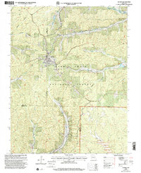
1999 Map of Bunker
USGS Topo · Published 2002About this map
Bunker serves as the central hub of this Missouri landscape, situated at the intersection of Dent Co Reynolds Co and Dent Co Shannon Co boundaries. The area is defined by the dense woodlands of the Mark Twain National Forest and the Sinkin Experimental Forest, where timber remains a primary industry as evidenced by the local Sawmill. Deep hollows like Ottaway Hollow and Gordon Hollow cut through the terrain, leading toward the West Fork Black River and Big Creek.
Find a feature on this map
35 named features on this map. Tap any name to fly to it.
Don’t see what you’re looking for? This feature index may not catch every label — zoom into the map to look around manually.
Map Details
Editions of this 1999 Bunker Map
This is the sole edition of this map. No revisions or reprints were ever made.
Other maps of this area

1941 · Stone Hill
USGS Topo · 1:62,500

1943 · Boss
USGS Topo · 1:62,500

1944 · Corridon
USGS Topo · 1:62,500

1945 · Stone Hill
USGS Topo · 1:62,500

1945 · Round Spring
USGS Topo · 1:62,500

1946 · Boss
USGS Topo · 1:62,500

1947 · Sinkin
USGS Topo · 1:48,000

1947 · Corridon
USGS Topo · 1:62,500

1949 · Round Spring
USGS Topo · 1:62,500

1949 · Rolla
USGS Topo · 1:250,000