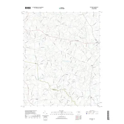
2019 Map of Bunn West
USGS Topo · Published 2019About this map
The boundary between Franklin Co and Wake Co meanders alongside the course of Moccasin Cr, defining the rural landscape of this central North Carolina region. Small agricultural and residential communities such as New Hope, Five Points, and Pearces are interconnected by a dense network of secondary roads, many bearing family names that indicate long-standing local history. The eastern edge of the survey captures the western portion of Bunn, while other settlements like Riley and Hopkins anchor the southern reaches of the map. Water management and local geography are highlighted by several significant ponds and reservoirs, including Bailey Lake, Dukes Lake, and Bakers Pond. These features, along with the drainage of Norris Cr and Crooked Cr, illustrate the hydrography that has shaped the area's development from its agrarian roots into the twenty-first century.
Find a feature on this map
133 named features on this map. Tap any name to fly to it.
Don’t see what you’re looking for? This feature index may not catch every label — zoom into the map to look around manually.
Map Details
Editions of this 2019 Bunn West Map
This is the sole edition of this map. No revisions or reprints were ever made.
Other maps of this area

1902 · Spring Hope
USGS Topo · 1:62,500

1904 · Springhope
USGS Topo · 1:62,500

1953 · Raleigh
USGS Topo · 1:250,000

1953 · Greensboro
USGS Topo · 1:250,000

1954 · Greensboro
USGS Topo · 1:250,000

1954 · Raleigh
USGS Topo · 1:250,000

1962 · Greensboro
USGS Topo · 1:250,000

1966 · Greensboro
USGS Topo · 1:250,000

1967 · Knightdale
USGS Topo · 1:24,000
1967 · Rolesville
USGS Topo · 1:24,000