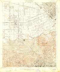
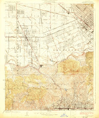
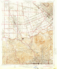
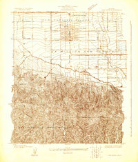
1926 Map of Burbank
USGS Topo · Published 1932About this map
The San Fernando Valley landscape is captured here in the mid-1920s, showing a critical transition from agricultural ranch land to the suburban and industrial hubs of modern Los Angeles. The town of Lankershim is central to this development, serving as a primary rail junction where the Southern Pacific and Pacific Electric lines converged. To the south, the emergence of the entertainment industry is evident at Universal City, while the iconic Hollywood Bowl and Hollywood Lake anchor the base of the Santa Monica Mountains. The map traces the early engineering of the region, from the route of the Mulholland Highway winding through the hills to the Power Line corridors and the containment of the Los Angeles River. Small stops like McNeil and La Paco dot the rail lines, marking a time before the rapid post-war urbanization obscured these smaller rural identities.
Find a feature on this map
42 named features on this map. Tap any name to fly to it.
Don’t see what you’re looking for? This feature index may not catch every label — zoom into the map to look around manually.
Map Details
Editions of this 1926 Burbank Map
3 editions found
Other maps of this area

1894 · Los Angeles
USGS Topo · 1:62,500

1896 · Santa Monica
USGS Topo · 1:62,500

1898 · Santa Monica
USGS Topo · 1:62,500

1900 · Los Angeles
USGS Topo · 1:62,500

1901 · Southern California Sheet No. 1
USGS Topo · 1:250,000

1902 · Santa Monica
USGS Topo · 1:62,500

1904 · Southern California Sheet No. 1
USGS Topo · 1:250,000

1920 · Santa Monica
USGS Topo · 1:62,500

1921 · Santa Monica
USGS Topo · 1:62,500
1924 · Van Nuys
USGS Topo · 1:24,000