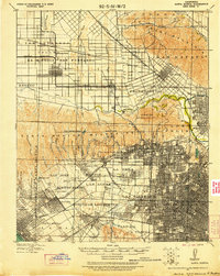
1921 Map of Santa Monica
USGS Topo · Published 1921About this map
The Salt Lake Oil Fields sit at the heart of this landscape, marking a period when petroleum extraction defined the transition between the basin's developing urban centers. This 1921 revision, updated using a Bagley Aerial Camera, reveals the extensive rail infrastructure of the Southern Pacific and Pacific Electric lines connecting emerging districts like Lankershim and Van Nuys to the coast. The map illustrates the lingering boundaries of Spanish land grants, such as Rodeo de Las Aguas and Ex Mission San Fernando, which still dictated the spatial organization of the region even as modern subdivisions like Beverly Hills and Culver City began to take shape.
Find a feature on this map
74 named features on this map. Tap any name to fly to it.
Don’t see what you’re looking for? This feature index may not catch every label — zoom into the map to look around manually.
Map Details
Editions of this 1921 Santa Monica Map
3 editions found
Other maps of this area

1894 · Los Angeles
USGS Topo · 1:62,500

1896 · Pasadena
USGS Topo · 1:62,500

1896 · Redondo
USGS Topo · 1:62,500

1896 · Santa Monica
USGS Topo · 1:62,500

1896 · Downey
USGS Topo · 1:62,500

1898 · Santa Monica
USGS Topo · 1:62,500

1899 · Downey
USGS Topo · 1:62,500

1900 · Pasadena
USGS Topo · 1:62,500

1900 · Tujunga
USGS Topo · 1:62,500

1900 · Los Angeles
USGS Topo · 1:62,500